Montag, 1. November 2010

Cardada – Locarno – Tessin - Schweiz


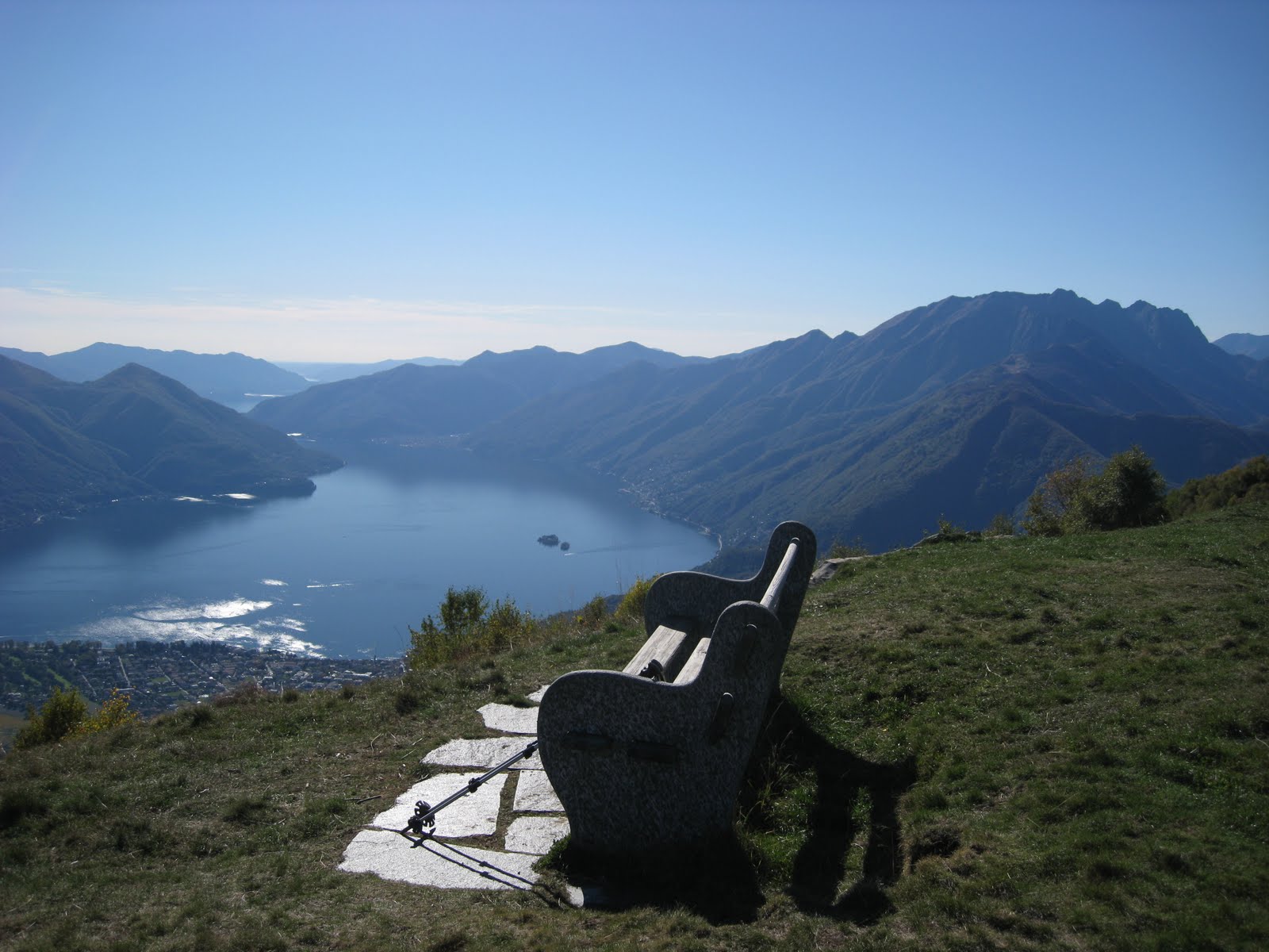
Im Süden der Schweiz gibt es im Herbst noch viele schöne Sonnentage. Vor einer Woche noch war ich auf dem Aussichtspunkt „Cardada“ oberhalb Locarno (siehe Bild). Von diesem Aussichtspunkt aus sieht man den tiefsten und den höchsten Punkt der Schweiz! Der tiefste Punkt der Schweiz ist Ascona mit 198m ü.M. und der höchste Punkt mit 4’634m ü.M. ist die Dufourspitze im Monte Rosa Massiv. Wahrlich ein interessanter Punkt!

In the south of Switzerland you have the possibility to see the highest and the lowest point of Switzerland. On the “Cardada” near Locarno in the canton Tessin you see the village Ascona which is only 198m above see level. From this point you can see also the “Dufourspitze” with 4’634m above see level in the Alps of the canton Wallis. Switzerland is a small country with only a surface aera of 41’285km2.

Au sud de la Suisse vous avez la possibilité de voyez le point le plus bas et le point le plus haut de la Suisse. Sur le « Cardada » près de Locarno vous voyez Ascona qui est seulement 198m sur mer. Et dans le même moment vous voyez le « Dufourspitze »dans le massif « Monte Rosa » avec une hauteur de 4’634m sur mer ! Alors vraiment un point extraordinaire !

Freitag, 1. Oktober 2010

Engadin – Bernina Gruppe


Der einzige Viertausender im Kanton Graubünden ist der Piz Bernina. Die beste Sicht auf die grandiose Szenerie dieser Berggipfel hat man vom Piz Languard aus. Der Piz Languard befindet sich oberhalb Pontresina und ist von der Alp Languard in ca. 3 Stunden erreichbar. Diese Foto (aufgenommen am 23. Spetember 2010 auf 3'200m ü.M.) zeigt das „Ensemble“ (von links) Piz Palü, Bella Vista und Piz Bernina (in der Mitte des Bildes) mit 4’049m ü.M. und Piz Scerscen.

In the east of Switzerland you see only one mountain over 4’000m above sea level. This is the montain named Piz Bernina with 4’049m above see level (in the middle of this picture). This picture I have taken from the Piz Languard 3’200m above sea level.

Dans le Grison il ya que une montagne qui est plus haut que 4'000m. C’est le Piz Bernina 4’049m dans la région du Pontresina. Vous voyez cette montagne au millieu du foto ci-dessus. J’ai faisais cette image au sommet du Piz Languard 3'200 s.M.

Donnerstag, 2. September 2010

Wallis – Grosser Aletschgletscher


Der Aletschgletscher ist der flächenmässig grösste und längste Gletscher der Alpen. Die Länge beträgt 23km und die Fläche einschliesslich der Quellgletscher beträgt ca. 86km2. Seine Dicke beträgt am Konkordiaplatz ca. 900m. Auf Grund der allgemeinen Erd- Erwärmung hat die Eisdicke seit 1850 um teilweise über 100m abgenommen. Eine Wanderung von der Riederfurka durch den Aletschwald ist wunderbar! Das Bild zeigt – auf dem Höhenweg von der Riederfurka aus aufgenommen - den Aletschgletscher und im Hintergrund die Fiescherhörner. Die Aletschregion gehört zum UNESCO Welterbe. (english and french see below)

The largest glacier of the alpes is the Aletschglacier. Lengh: 23km – Surface aera 86km2!If you have the possibility to discover this UNESCO World heritage – do it! The picture show the glacier and the Fiescherhörner in the Background.

Dans le Valais, il ya le plus grand glacier des alpes, le glacier d’aletsch. Il ya une surface de 86km2 est la longeur est 23km. Si vous voulez faire une randonnée dans cette region exeptionelle : vous commencez à « Riederalp » et vous traversez cette patrimoine mondial UNESCO en environs 3 – 4 heures.

Sonntag, 1. August 2010

Wallis - Nanztal


Das unberührte Nanztal liegt zwischen dem Simplonpass und Visperterminen. In etwa 6 Stunden kann man von Giw, welches oberhalb Visperterminen liegt zum Simplonpass wandern. Der Weg führt an der „Heida“ Wasserleitung vorbei. Diese künstlich angelegten Wasserleitungen dienen dem Bewässern der Felder von Visperterminen. Im Bild das schneebedeckte Fletschhorn ( 3’927m ü M) und im Vordergrund die „Heida“ Wasserleitung.

27 four thousand metre peaks, impressive glaciers, deep gorges and an 8,000km hiking network invite you to discover tranquil paths in Valais. The picture shows the Nanz-Valley. A very good Idea for hiking!

Dans le Valais, entre le col du simplon et Visperterminen il ya le pittoresque « Nanz – Vallée ». Si vous voulez faire une randonnée calme, visitez le Nanz-Vallée ! L’image montre le petit fleuve (suonen) pour arroser les terrains du Visperterminen et au fond on voit le Fletschhorn (3’927m s.m.)

Donnerstag, 8. Juli 2010

Allgäu – Bodensee - Staufner Haus


In der Nähe von Oberstaufen im Allgäu (Süd – Deutschland) liegt der Hochgrat auf 1833m ü.M. Etwas unterhalb befindet sich das Staufner - Haus des DAV (Deutscher Alpen Verein). Von der Talbahnstation der Hochgrat – Bahn erreicht man in etwa 4 Std Wanderung über die Brunnenau Scharte das Staufner Haus. Am Abend schweift der Blick über die Höhenzüge des Allgäu’s bin hin zum Bodensee (siehe Foto). Der Bodensee hat eine Oberfläche von 535 km2

In Germany you have also the posibiltiy to hike. In the southern region of Germany – in the “Allgäu” you can hike to the “Staufner House”. In the evening you have a lovely view over the montains until to the lake Constance. The lake Constance has a surface of 536 km2

En Allemagne il ya la région « Allgäu ». Si vous avez la possibilité de visiter cette région, profitez de la vue sur le « Staufner-Haus » (voyez foto). Vous voyez non seulement les alpes de la région mais encore le lac de Constance. Ce lac il y a une surface de 536 km2!

Montag, 7. Juni 2010

Wanderung auf das Albishorn


In der Nähe von Zürich liegt der Albis Höhenzug. Vom Albishorn aus hat man – obwohl nur 900m ü.M. - eine schöne Aussicht auf den Zugersee (siehe Bild) und die Zentralschweiz. Bei schönem und klarem Wetter sieht man sogar die Berner Alpen mit Eiger-Mönch und Jungfrau.

In Springtime you have the posibiltiy to hike to the Albishorn near Zurich. The Albishorn is only 900m above see level, but you see the lake of Zug and a lot of mountains for example the Eiger, Mönch and Jungfrau.

Si vous avez la possibilité de visiter Zurich c’est vraiment une formidable idée de faire une randonnée sur le Albishorn. Le Albishorn est seulment 900m.s.M. Vous avez une belle vue sur les montages, les lacs est les prairies du printemps.

Samstag, 29. Mai 2010

Basel - Stadtwanderung


Im Frühling empfehle ich Ihnen einmal als Abwechslung eine Stadtwanderung in Basel zu unternehmen!

In Springtime you have also the posibiltiy to visite a Town. My proposition is Basle!

Je vous propose de visiter Bâle en printemps pour faire une petite randonné!